Sunday, October 11, 2020

Ruth Botel's Cape Scott Map


 Map of settlement in the Cape Scott area by Ruth Botel. Ruth was a North Island historian who passed away in 2018.  Reproduced with permission of her daughter Sandra Botel.

Saturday, May 30, 2020

The mysterious marble shrine at Nimpkish Camp

In the bush, in the area around Nimpkish Lake, there is a marble monument, which seems quite out of place in the middle of the dense forest, with no indication that a hiker were to come upon it.


I have been told it was a labour of love, built by a man who emigrated from Italy and worked in the logging industry. Apparently his plan was to bring over his childhood sweetheart when he had earned enough money, but she died before she was able to come to Canada. Her name was Maria Rei.

The monument was built in the late 60s and early 70s, and at one time included a statue of the Virgin Mary. Either the statue that was a part of this monument, or perhaps a separate one, was donated to St. Bonaventure Catholic Church in Port Hardy. 


The artist was Rufino (Manny) Mancinelli, who was a "welder, barber, and sculptor" who worked in a local logging camp. When the camp closed the area was overtaken by the North Island rainforest.

Photo of Rufino (Manny) Mancinelli displaying another of his talents, as the Camp barber.
 If you do visit the monument, please be respectful and take care not to damage it, so that it can be enjoyed by future generations.

Sunday, April 19, 2020

Varney Bay - Quatsino Sound


Ethel (1869-1957) and (Thomas) Henry (1869-1952) Varney took up a pre-emption in Varney Bay in 1897 and had nine children. They lived on their homestead for about 50 years.
Varney, who was rumoured to come from a titled English family, was well known in the community and sometimes referred to as "Lord Varney." He held various government jobs and led some projects such as a road-building crew in the community.
A number of their children died tragic deaths. Philip and James died in a boating accident at the mouth of Quatsino Sound, and Fred passed away in a plane crash in Port Hardy.
Ethel and Henry are buried in the Royal Oak Burial Park Cemetery in Victoria BC. 


Their daughter, Dinah Varney, born on the North Island in 1907, never married. She helped care for the homestead and even into her old age was still taking care of a large garden. A strong and self-reliant pioneer woman, when she was 57 she was still running a 12 mile trap line, and was known for bringing down 19 cougars.
Dinah Varney's house in Varney Bay by the mouth of the Marble River - undated. BC Archives F-05834


#VarneyBay #QuatsinoSound

Sunday, May 12, 2019

Nootka Packing Company Ltd.

A fish saltery was opened in the area of Yuquot / Friendly Cove on Nootka Island in the late 1800s.

The cannery was built just about one mile North of this location in 1917 and operated as the Nootka Packing Company Ltd., canning razor clams, pilchard, and herring. Some reports say the cannery employed up to 2000 people at capacity. 

Nootka Island Cannery 1938
BC Archives E-07910
Indigenous workers' houses to the rear of the cannery at Nootka 1930s
BC Archives A-08869
1940
Jewish Museum and Archives of BC Item L.13201
It closed around 1950 when fishermen were no longer able to catch pilchard off the coast at their previous levels of abundance.

Nootka Cannery 1940
BC Archives E-07909

In the 1960s visitors to the canneries were able to find many of the old original labels from the cannery still in the buildings.

Deserted Nootka Cannery, 1964.
UNBC Archives Item 2013.6.36.1.003.016
Today a fishing lodge operates at the location of the old cannery.

Friday, February 15, 2019

Kla-anch River


In the late 1800s Southern Vancouver Island was becoming more inhabited, and people began to explore the North Island in earnest. Some came to scout out good farming areas, and many were prospecting. In the late 1800s and early 1900s some adventurous explorers came to the Nimpkish watershed to try out the fishing. At this time Nimpkish Lake, and the Upper Nimpkish River were known as Karmutsen or Kla-anch.


Perhaps most famously, Roderick Haig-Brown wrote in A River Never Sleeps: "...In 1928 I caught a real January steelhead in the Kla-anch River on Vancouver Island. The Kla-anch, which is sometimes called the Upper Nimpkish, is the largest stream flowing into Nimpkish Lake, and is a hard river to know for several reasons. It is a very long river, scattered with pools that are not often easy to approach; it comes into heavy freshet rather quickly and easily,and it is an isolated river in a totally unsettled area; so that few people have fished it,and anyone who goes there to fish must gather his own local knowledge as he goes along... One day the road will reach there, and then the fishermen will learn the river and name the pools."
Kla-anch River - 1914

BC archives : Ref: NA-04255

Saturday, January 19, 2019

Canneries in Quatsino Sound

Jobe Leeson opened the Winter Harbour Canning Company in 1904, hiring mostly Chinese workers, across the inlet from the community at Winter Harbour. He canned clams and crab.
VPL Accession Number: 14134 - The Leeson cannery in Winter Harbour

VPL Accession Number: 14145 - Women preparing clams


VPL Accession Number: 13959 - Winter Harbour Canning Co.

In 1911 he sold to Wallace Fisheries who moved the cannery to Mahatta.  The cannery struggled as Quatsino salmon stocks supported limited populations and really only produced economically viable numbers of fish every second year.  Its focus was on salmon and pilchard. 

VPL Accession Number: 13913 - Wallace Fisheries Ltd. Quatsino

VPL Accession Number: 13905 -Interior of the Wallace Fisheries Cannery. 


After closing briefly in 19917 the plant re-opened. The Mahatta plant changed ownership twice before being sold to BC Packers in 1928. In addition to canning, a reduction plant operated at the site up to 1930. In 1934 the plan was closed and the buildings were torn down. 
Koprino Cannery - Used with permission of the Canadian Fishing Company Archives.


The Koprino Cannery also operated in Quatsino Sound in this period. It was built in 1927 by Canfisco - the Canadian Fishing Company. Like the Mahatta plant it offered both canning of fish and a reduction plant. The plan closed in 1930 when pilchard disappeared from the coast. 

Sunday, January 13, 2019

Port Neville

This incredible historical photo of the week shows a forest fire threatening the town of Port Neville on June 25, 1925. Port Neville is located across Johnstone Strait just North of Kelsey Bay/ Sayward and is within the traditional territory of the Tlowitsis Tribe. Hans Hansen was the first non-Indigenous settler to locate to Port Neville in 1891, and a settlement which served as a stop for coastal steamships was established in 1892. The post office operated until 1910.
Port Neville June 25, 1925
City of Vancouver Archives: AM54-S4-: Tr P45
Port Neville June 25, 1925
BC Archives NA-04977
Logging railway Port Neville (early 1900s)
Item NA-03814

https://www.campbellrivermirror.com/community/historic-port-neville-calm-port-in-a-story/

Wednesday, December 26, 2018

The Early History of Alert Bay

Cormerant Island was initially a part of the territory of the 'Namgis First Nation, who lived in the village of Whulk (Xulku) on the banks of the Nimpkish River.  The Island, which was known as Yalis, had been used as a canoe pullout, and an important berry harvesting location by First Nations for thousands of years before non-Indigenous settlers arrived.
In 1862 a fish saltery was built in Alert Bay by Mack and Neill. The operation targeted Nimpkish River fish, specifically sockeye. Seasonal processing would employ many local Indigenous people. At about the same time, a Christian mission and school which had briefly been established at Fort Rupert moved to Alert Bay to minister to the Indigenous population which was moving to the island to work in the cannery.
At the time S.A. (Steven Allen) Spencer also owned a photography studio in Victoria, however in 1885 he moved to Alert Bay and developed a cannery, known as the (S.A.) Spencer & (Thomas) Earle cannery. It was the first cannery built between the Skeena River and the Fraser River along the British Columbia coast.
A-04489 - BC Archives - Alert Bay Cannery - 188?

A plant to construct boxes for fish processing plant was constructed in Telegraph Cove.
Cannery at Alert Bay 189? - BC Archives - C-04957
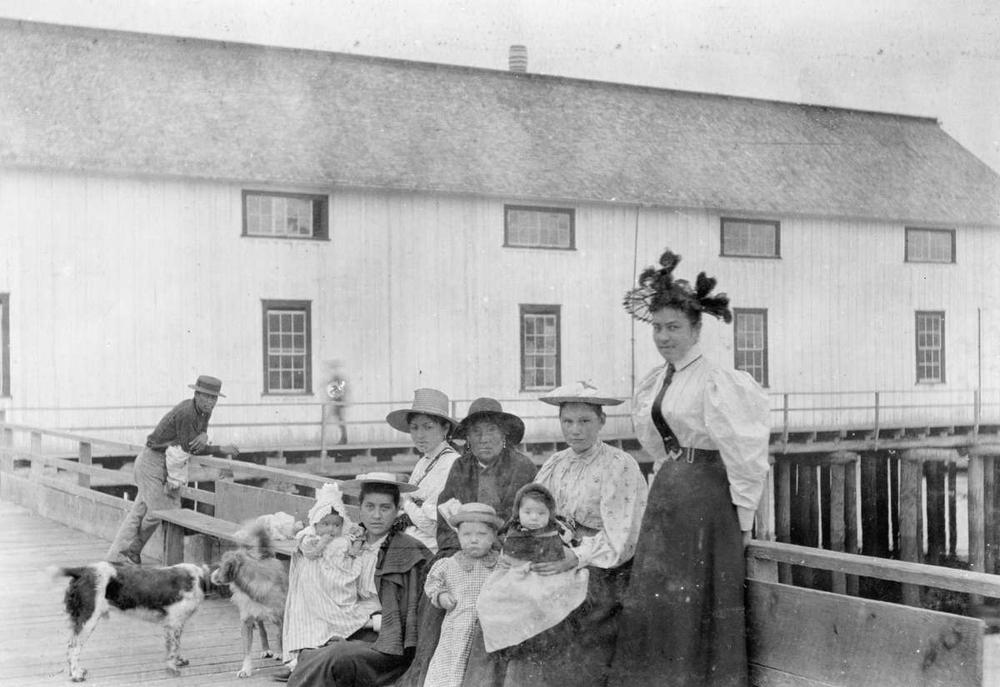
A group in front of Spencer's cannery 1896. BC Archives I-31533

In 1902 the cannery was sold to the British Columbia Packers Association.
Alert Bay Cannery 191? BC Archives I-31533
Earle sold his share of the cannery in 1894 and the cannery was renamed The Alert Bay Canning Company. Spencer also reportedly served as the Alert Bay postmaster before retiring to Victoria.
"Fresh Nimpkish River Salmon, Alert Bay Canning Co." (1910) BC Archives I-60014.

"History of the Alert Bay Plant" 1940 http://digital.library.mcgill.ca/hrcorpreports/pdfs/B/British_Columbia_Packers_Ltd_1940.pdf

Tuesday, December 11, 2018

Vicks' Store, Fisherman Bay, Cape Scott

In the late 1800s, Danish settlers at Cape Scott set up an initial Co-operative Store at Fisherman Bay, at Nissan Bight. By 1907 the coastal steamships were no longer stopping at Fisherman Bay, and the store closed in 1909 as many of the original settlers left the community. A few years later, with an influx of new settlers living on pre-emption's dotted along the North Island's coastline, the store re-opened and was run by Archie Darlington and then the Vicks family. It again closed in about 1916.

Vicks' Store at Fisherman Bay (circa 1914) City of Vancouver Archives  P1153.4  

Friday, December 7, 2018

Steam Donkey in Quatsino Sound


This week's North Island historical photo shows a logging crew, three uniformed members of the Armed Forces, and an unidentified woman posing with a steam donkey. The photo was taken in Quatsino Sound by Ben Leeson in the early 1900s.
From the mid-1880s, when they were invented, until about 1920, most steam donkeys were powered by a fire which created the steam. One person's job was just to manage the firewood to keep the boiler running. For a short period after that some donkeys ran on oil powered engines. Steam donkeys were an essential piece of coastal forestry equipment until about the 1930s, enabling loggers to pull logs through the woods, therefore leading to logging moving from steep coastal areas to more inland locations.
VPL14001

Thursday, December 6, 2018

Kains Island Light Station

The first light station was established at Kains Island, at the mouth of Quatsino Sound in 1905.  At the time the Inlet was becoming a bustling centre of industry and the site of numerous homesteads, pre-emptions, and settlements. At times the mouth of the Sound was easy to pass by, as was evidenced by Captain Vancouver's early charts which missed identifying Quatsino Sound completely. The initial light station was unmanned.
VPL Accession Number: 14135
A more permanent light was established in 1910, and Quatsino Sound resident Nels C. Nelson and his wife moved in as the first resident light keepers.

This photo includes Mr & Mrs Nelson in 1911.

VPL Accession Number: 14154
An excellent account of the history of the Kains Island Light Station is provided on the Lighthouse Friends website: http://lighthousefriends.com/light.asp?ID=1195 .

Sunday, December 2, 2018

Sealing Schooner Diana in Quatsino Sound

This photo of the sealing schooner Diana, was taken in Quatsino Sound in about 1896 by Ben Leeson of Winter Harbour/Quatsino. Until the start of the first world war there was a thriving sealing industry in the Bering Strait, and about 50 vessels engaged in the fishery had their home port in BC. Many of the crews were Japanese Canadians. Indigenous people from the North Island were also recruited as crew on the sealing ships because they were good hunters with excellent ocean experience. West Coast Indigenous peoples generally were also experienced whalers.

Sealers would sometimes be away for months at a time, and could travel as far as to Japan on a seasonal trip. There are stories about some of the first people of European heritage to attend a potlatch in Quatsino Sound who were quite surprised to find Indigenous women dressed in kimonos, which had been obtained by men working in the sealing industry.


BC Archives H-04069

Friday, October 19, 2018

Kwakwaka'wakw Dancers of Fort Rupert

This week's North Island historical photo is called "Indian Dancers of Fort Rupert," taken about 1896. Within the big house, large elaborate dances and productions were an important part of the Kwakwaka'wakw culture. Some of the stories portrayed killings and even cannibalism, at times this would include the resurrection of a murdered person or supernatural being. Special effects, such as tubes running under the ground, special material thrown into the fire to make smoke or explosions, and other special effects were used to create an amazing experiences for audiences. Some of the first people to record seeing these events in English expressed their shock and horror at events that were both very scary and seemingly magic.
BC Archives H-04849

Sunday, October 14, 2018

RCAF Station Coal Harbour

Previously a small outpost, Coal Harbour became a bustling Royal Canadian Air Force Station during World War II. When the base shut down in 1945 much of the military infrastructure was dismantled, and a small maintenance crew remained. Much of the infrastructure became a busy whaling station. As was the case at the Port Hardy base, many airmen who brought their wives to the base built their own cabins and lived in their own houses. These houses are identified as the homes associated with the RCAF Station, although the photo is dated 1947 and most of the members of the air force would no longer have been on the North Island at this time.

BC Archives g-03958


When World War II broke out, Canada perceived a threat on its Pacific Coast from the Japanese. In 1940 the government authorized the establishment of a Royal Canadian Air Force Station at Coal Harbour. The station supported both initially radio operators, and eventually the No. 120 Bomber Reconnaissance Squadron.
BC Archives a-142512

BC Archives a-142516

Coal Harbour's 'Jokerville' BC Archives g03242
Although the 'Jokerville' in Port Hardy is better known, the Air Force employees in Coal Harbour also constructed makeshift cabins just off the base so that their wives could join them during their posting. At its height during the war, the population of Coal Harbour reportedly reached about 1500 people. This was a big change for the small outpost, which spent the previous 50 years mainly as a terminus of the Port Hardy - Coal Harbour trail/road and home to the Hole's hotel & store. In 1927 the Port Hardy - Coal Harbour road became passable by motorized vehicles, it wasn't until the Island Copper Mine opened that the road was paved.
BC Archives G03241


Monday, October 1, 2018

The Steamship Beaver

An icon of the BC Coast, the Steamship Beaver was originally built in England in 1835. Able to proceed under either sail or steam power (via a side paddle wheel), she heralded a new era of coal powered vessels on the Pacific Coast.

The SS Beaver arrived in British waters in the Pacific Northwest in 1836, and in 1837 William Henry McNeill took over as her Captain. As steam power began to replace sail as the preferred mode of transport, the economy and trade on Vancouver Island shifted from the fur trade to the search for reliable sources of clean coal. This resulted in the establishment of Fort Rupert at Beaver Harbour (today Port Hardy), and Fort Nanaimo.

The SS Beaver played a prominent role in early coastal history, serving the needs of the Hudson's Bay Company, transporting trade goods, and shuttling dignitaries around the South Coast until it foundered on the rocks off Prospect Point in Stanley Park in 1888.

Beaver Harbour in Port Hardy and Beaver Cove in Port McNeill are named after this ship. Port McNeill is named after her early Captain, William Henry McNeill, who was also for a time the Chief Factor at Fort Rupert.

Saturday, September 15, 2018

US Air Force Drops Bomb off BC Coast

On February 13/14, 1950, during a mock nuclear bomb drop training exercise, two US Air Force planes departed from Alaska en route to Texas. Their flight plan was to keep them out of Canadian air space until they would come toward land to conduct manoeuvres over California. It was bitterly cold in Alaska, and from take-off the planes began to suffer a number of malfunctions.

As the planes approached Haida Gwaii it became apparent that a B 36 Bomber, carrying a Mark IV atomic bomb, was going down. The plane had multiple engine failure. The US Air Force was under strict orders not to let their bomb technology fall into enemy (Russian) hands, and the crew jettisoned the bomb over the Pacific Ocean (reportedly without the fuse device that would ignite a nuclear explosion) before parachuting down over the Inside Passage. There were 17 crew members on board, and 12 were rescued after they were found on Princess Royal Island.
 The crew were taken to Port Hardy, where the historical photo of the week shows them warming up after their ordeal. 

The plane, originally thought lost in the ocean, was eventually located near Smithers, BC. For more information about the crash check out the book Lost Nuke: The Last Flight of Bomber 075 by Dirk Septer.
http://scalar.usc.edu/works/brokenarrowproject/map-of-missing-british-columbia-bomb---1

Friday, September 7, 2018

Seaweed harvesting in Smith Inlet

This historical photo of the week shows an Indigenous woman drying seaweed. She is not identified in the photo. This picture is credited to Clifford R. Kopas, believed to be taken while he was travelling on the CPR steamship Cassiar in the 1920s or 1930s in Smith Inlet. Local First Nations have harvested many resources from the ocean and land for thousands of years, often travelling around their territory seasonally to harvest various items at preferred traditional locations.


Wednesday, September 5, 2018

Construction of the first dock at Port Alice

Over 100 years ago the Quatsino Power and Pulp Co. began development of a mill in Port Alice in order to process the vast timber resources in the Quatsino Sound area. The company changed hands a couple of times during the war years, but Whalen Pulp and Paper Mills did complete the construction of the mill and a townsite by 1918. This historical photo of the week shows the construction of the original Port Alice dock, circa 1916. Photo by Ben Leeson.